Great Lakes Moment is a monthly column written by Great Lakes Now Contributor John Hartig. Publishing the author’s views and assertions does not represent endorsement by Great Lakes Now or Detroit PBS.
The Eastern Seaboard has the East Coast Greenway and the Appalachian Trail. The Western Seaboard has the Pacific Crest Trail. The Rocky Mountains have the Continental Divide Trail. Right now, the Council of State Governments, Midwestern Office (CSG Midwest) is working with the eight Great Lakes states, and other trail partners, to explore creating a U.S. Great Lakes Waterfront Trail to meander along the shorelines of the largest freshwater system on Earth.
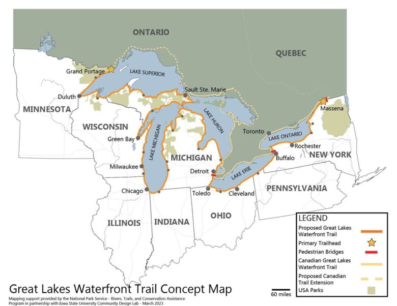
Imagine a trail of national significance connecting visitors and residents to 20% of the standing freshwater on the Earth’s surface. This is precisely what is being envisioned as the U.S. Great Lakes Waterfront Trail, showcasing the history, ecology and culture of this bioregion. It will also have several connections to Canada’s Great Lakes Waterfront Trail.
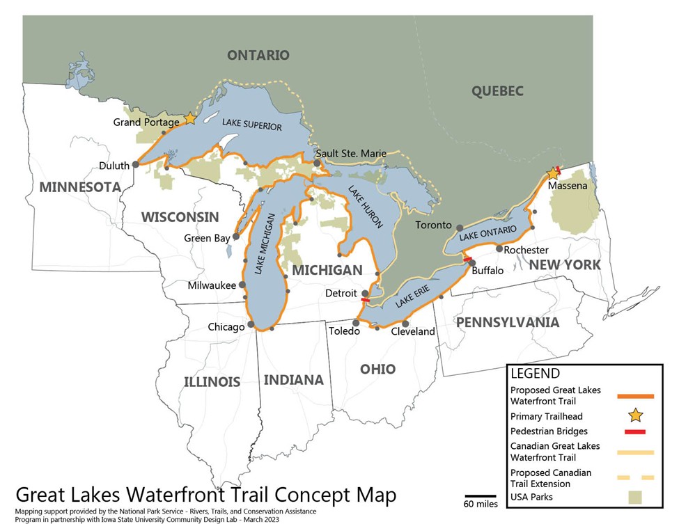
Examples of transboundary trail crossings include:
- The Seaway International Bridge connecting Cornwall, Ontario and Massena, New York.
- The Peace Bridge connecting Fort Erie, Ontario and Buffalo, New York.
- The soon-to-open Gordie Howe International Bridge connecting Windsor, Ontario and Detroit, Michigan.
- The Grand Portage-Pigeon River border crossing that connects Grand Portage, Minnesota with Neebing, Ontario.
This trail will be a collaborative effort among the eight Great Lakes states, building on the foundation of existing and planned trails, over time completing trail gaps. The goal will be to welcome as many non-motorized users as possible and provide unforgettable trail experiences along the Great Lakes.
CSG Midwest is leading this initiative through an ongoing set of roundtable discussions among the eight Great Lakes states and other key trail organizations. A consensus vision provides direction to this initiative: all residents and visitors of the eight Great Lakes states are connected to and benefit from world-class freshwater, wildlife, recreation and history through the U.S. Great Lakes Waterfront Trail.
Canada’s Great Lakes Waterfront Trail has been in existence for more than three decades. This Ontario trail stretches from Lake Superior to the St. Lawrence River at the Ontario-Québec border — approximately 2,250 miles. It is a greenway route of interconnecting roads and off-road trails. This greenway system will join 177 communities along the Canadian Great Lakes and St. Lawrence River waterfronts — including Indigenous nations.
A celebration of nature and culture, the Canadian Great Lakes Waterfront Trail is part of a strategy to protect the largest group of freshwater lakes on Earth and connect people to them. It is a legacy project of the Waterfront Regeneration Trust, a charity, and its community partners.
The long-term goal of Canada’s Great Lakes Waterfront Trail is to be as close to the water’s edge as ecologically feasible. Today, 13% of this route is dedicated paths and quiet residential streets, 76% is on secondary roads (often in rural and northern regions), and 11% is on provincial highways with enhanced shoulders.
Canada’s Great Lakes Waterfront Trail uses interim routes to achieve connectivity, which is critical to motivating community participation and ensuring public confidence in the initiative. Trail communities and the Waterfront Regeneration Trust work continuously to improve trail alignment and expand the connections to and from the trail.
No such meandering greenway route currently exists along the U.S. shoreline of the Great Lakes, although many segments of such a trail exist. That is why CSG Midwest is facilitating collaboration among the Great Lakes states and other trail organizations to create a U.S. version of the Great Lakes Waterfront Trail that will have connections to Canada’s.
In 2024, the initiative received a non-financial, technical assistance grant from the National Park Service’s Rivers, Trails, and Conservation Assistance (RTCA) program. Both RTCA landscape architects and Purdue University geographical information system experts are working with state partners to map this trail along 84 counties and complete a gap analysis.. RTCA is also assisting The Council of State Governments with facilitation and partnership-building.
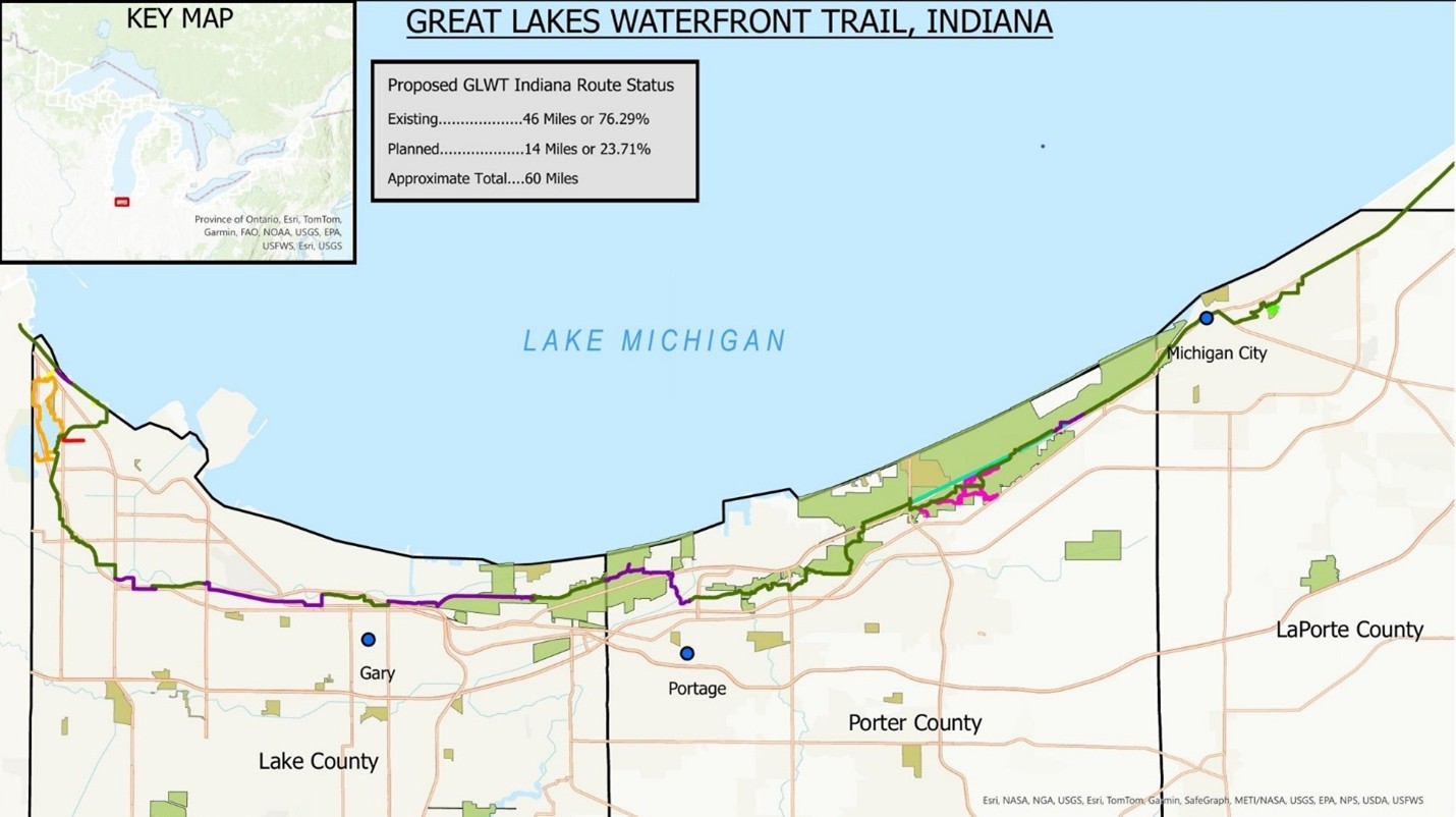
The first state to be mapped was Indiana. This trail is locally known as the Marquette Greenway and is approximately 60 miles long and 76% complete.
“Indiana will be honored to have the Marquette Greenway become part of the Great Lakes Waterfront Trail in the United States,” said Mitch Barloga, active transportation manager with the Northwestern Indiana Regional Planning Commission. “Being part of this Great Lakes Waterfront Trail initiative will help promote our portion of the greenway and will help bring more outdoor enthusiasts to and through our trail, accessing several popular destinations on Lake Michigan, which in turn will provide a boost to our local businesses.”
Preliminary maps have also been prepared for Pennsylvania, Illinois and Minnesota, soon to be followed by Wisconsin, Ohio and New York. Michigan will be the last state mapped because it has the most Great Lakes shoreline and, therefore, most challenging.
In addition, this initiative has received support from the University of Michigan’s School of Environment and Sustainability for an eco-design capstone project. Graduate students are helping Pennsylvania engage with local trail stakeholders and assess, synthesize and help design a trail system that is resilient, connected and rooted in place.
“CSG Midwest and the Great Lakes-St. Lawrence Legislative Caucus are excited to be facilitating this initiative to create a U.S. Great Lakes Waterfront Trail across our eight Great Lakes states,” said Jessica Lienhardt, Great Lakes Program Director, CSG Midwest. “With connections to Canada, it will become a continentally-significant, binational, recreational trail along the largest chain of freshwater lakes in the world, connecting communities and businesses along spectacular scenery.”
The benefits of this trail collaboration are enormous, including expanding outdoor recreation and ecotourism economies, promoting conservation, encouraging healthy lifestyles and enhancing quality of life.
It is well known that trails allow communities to increase commerce, support and create jobs, increase property values, reduce commuter costs, and provide low-cost health benefits.
Examples of economic benefits include:
- A 2019 Rails to Trails Conservancy report found that the net economic impact of trails in Wisconsin is as much as $1.5 billion USD.
- The Parks and Trails Council of Minnesota has reported that non-motorized trail users spend $2.7 billion USD annually and support 37,000 jobs in Minnesota.
- An economic benefits study of The Great Lakes Way in Michigan found that the total estimated economic impact of greenways, water trails, parks, unique natural areas, waterfront reclamation, connections to Canada, and historical and heritage attributes was approximately $3.75 to 5 billion USD annually.
- In 2023, the Trans Canada Trail released a report quantifying the world’s longest trail’s economic, environmental, and public health impacts. Based on this study, the total economic, environmental, and public health impacts of the Trans Canada Trail in Ontario (a large percentage of this is the Canadian Great Lakes Waterfront Trail) was $9.8 billion CAN.
CSG Midwest has thus far received letters of support or support statements from the Indiana Department of Natural Resources, the Great Lakes Commission, the Great Lakes-St. Lawrence Legislative Caucus, The Great Lakes Way, The Marquette Greenway, Northwest Indiana Regional Planning Commission, the Wisconsin Nonmotorized Recreation and Transportation Trails Council and the Great Lakes and St. Lawrence Cities Initiative.
If a local trail organization is interested in becoming a collaborator, please contact CSG Midwest at gllc@csg.org.
John Hartig is a board member at the Detroit Riverfront Conservancy. He serves as a Visiting Scholar at the University of Windsor’s Great Lakes Institute for Environmental Research and has written numerous books and publications on the environment and the Great Lakes. Hartig also helped create the Detroit River International Wildlife Refuge, where he worked for 14 years as the refuge manager.
Catch more news at Great Lakes Now:
Great Lakes Moment: Government downsizing, defunding and deregulating at what environmental cost?
Great Lakes Moment: Detroit River common terns under threat
[spb_video link=”https://www.youtube.com/watch?v=SLVIwzvmPCo” remove_related=”yes” autoplay=”no” full_width=”no” width=”1/1″ el_position=”first last”]
Featured image: Great Lakes Waterfront Trail concept map. (Photo Credit: Rivers, Trails and Conservation Assistance Program of the National Park Service)[php function=”remove_swift_shortcodes”]